Published March 13, 2014 12:00AM
No Raft Needed: Google's Digital Ride Down the Colorado River
Here's the good news and the bad news: You won't have to worry about sunscreen or getting pitched into the river.
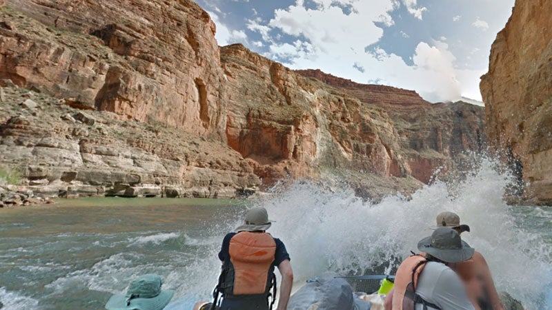
Hold on! The crew keep themselves in the boat through 36-mile Rapid.
You can now raft 286 miles through the Grand Canyon, from Lee’s Ferry to Pearce Ferry, without getting wait-listed—or even getting off of your couch. After surveying that iconic stretch of the Colorado River, Google today launched the wet ride on Google Maps.
“The main challenge during the trip was the weather,” she says. “Since you keep moving downstream, and can’t turn around to re-collect, when it rained, we continued to collect. The end result is some beautiful and amazing weather captured around Mile 65.”
ADVERTISEMENT
But the tech giant isn’t just scanning this stretch of the Colorado River to make a map. It’s using the occasion to create a platform for raising awareness around the threats that the Colorado River is facing, in the form of drought and outdated water management practices. That’s why American Rivers, the advocacy group that named the Colorado America’s most threatened river last year in its annual Most Endangered Rivers list, was involved in the project.
“It’s a snapshot in time,” says American Rivers spokesperson Amy Kober of the Street View map. As the river continues to evolve, the Street View map will serve as a benchmark. “This is what the beaches look like,” she says. “Those are the bathtub rings on the reservoirs, that is valuable information.”
This is hardly scientific data—the United State Geological Services and other agencies and institutions have been collecting that for decades—but it is a way for people who have never seen or been on the river to experience what are arguably its most iconic parts. That, says Kober, should stoke them to care more about its fate.
ADVERTISEMENT
Fortunately, through a treaty agreement between the U.S. and Mexico, an experiment will begin on March 23 that will temporarily flood the river’s southern (and parched) delta. Water will be released from the Morelos Dam, near where California’s, Arizona’s, and Mexico’s borders meet, for eight weeks. Conservation groups expect this relatively short period of flow could significantly improve habitat in the delta. American Rivers calls it a step in the right direction.